Kansas is a state with rich geographical diversity, from its sweeping plains to scenic byways and historical landmarks. Navigating through its urban hubs or traveling along its beautiful rural roads, having a reliable map is essential for experiencing all the Sunflower State has to offer. Kansas maps provide more than just direction; they offer a deep connection to the land, its history, and its natural wonders.
Maps are crucial for travelers, historians, and even locals wanting to uncover new aspects of Kansas. This article will highlight the various types of Kansas maps available, from road maps to historical and topographic ones, offering a deeper understanding of how these tools can guide your journey and enrich your appreciation of the state’s geography and culture.
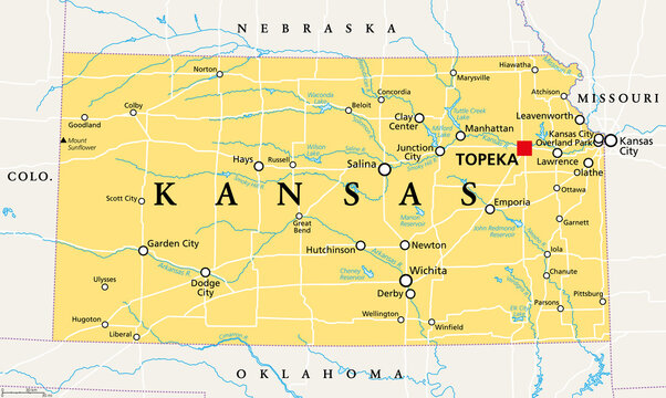
Overview Of Kansas’ Geography
Kansas lies in the heart of the Midwest, bordered by Nebraska, Missouri, Oklahoma, and Colorado. While often described as flat, the state features diverse landscapes, including the Great Plains, Flint Hills, and the Kansas and Arkansas rivers. The state’s eastern side offers rolling hills and forested areas, while the west is dominated by flat, expansive farmland. The Flint Hills, one of Kansas' defining regions, boasts the largest remaining tallgrass prairie in North America, offering a glimpse into the state’s natural beauty.
The state's location and topography have influenced its agricultural economy, earning Kansas a reputation as one of the largest producers of wheat and corn in the country. A Kansas mapreveals these agricultural plains as well as the highways and railroads that connect its major cities, including Wichita, Topeka, and Kansas City.
Kansas Road Maps - Navigating Highways And Scenic Byways
Kansas is home to an extensive network of highways, making road maps an essential resource for locals and visitors alike. Major highways like I-70 and I-35 connect the state’s largest cities, while local roads link smaller towns and rural areas. Kansas road maps are particularly helpful for planning cross-country trips or exploring specific regions within the state.
While navigating these highways, families can discover various attractions, including some of the best amusement parks in Kansas City. Kansas is also known for its scenic byways, which offer breathtaking views of the state’s diverse landscapes. The Flint Hills Scenic Byway, for example, takes travelers through one of the last remaining tallgrass prairies, while the Wetlands & Wildlife National Scenic Byway offers a glimpse of Kansas’ abundant wildlife.
Understanding Kansas Topographic Maps
Kansas is more than just flat land; its topographic maps reveal the state’s rolling hills, river valleys, and plateaus. While the Great Plains dominate much of Kansas, regions like the Flint Hills and Osage Cuestas provide unique topographic features worth exploring.
Topographic maps are especially valuable for outdoor activities like hiking, camping, and geocaching. They provide detailed information about the state’s elevations, water bodies, and landforms, helping adventurers navigate Kansas’ natural beauty with ease.
Historical Maps Of Kansas
Kansas’ history is deeply tied to its geography, and historical maps offer a fascinating look at how the state has evolved. Maps from the early 1800s show Kansas during its territorial days, when conflicts over slavery gave rise to the "Bleeding Kansas" period. As the state developed, railroad maps from the late 19th century highlight the growth of towns and agricultural expansion.
In today's digital landscape, the role of a content editor is crucial in curating and presenting such historical information effectively. Historical maps also offer insights into Kansas’ role in westward expansion, with trails like the Santa Fe Trail and Oregon Trail clearly marked. These maps are a treasure trove for historians, educators, and anyone interested in understanding how Kansas’ landscape shaped its history.
Political Maps Of Kansas - County Boundaries And Districts
Kansas is divided into 105 counties, each with its own government structure. Political maps of Kansas clearly outline these county boundaries, making it easy to see how the state’s local governance is organized. These maps are helpful for understanding the state’s political divisions and are particularly useful during elections when district boundaries come into play.
In addition to counties, political maps also show the location of key cities like Topeka (the capital), Wichita, and Kansas City. These maps help residents and researchers alike understand the state’s political and population distribution.
Tourist Maps Of Kansas
Kansas may be known for its agriculture, but its tourist attractions are diverse and worth exploring. Tourist maps are a fantastic resource for visitors, showcasing the state’s best destinations. The Tallgrass Prairie National Preserve, one of the most extensive prairies in North America, is a popular spot for hikers and nature lovers. The Eisenhower Presidential Library and Museum in Abilene offers a look into the life of one of America’s most notable presidents.
In the digital age, leveraging SEO toolscan enhance visibility for these attractions, making it easier for tourists to discover them online. Other attractions include the Kansas Cosmosphere and the Wizard of Oz Museum, both of which draw visitors from across the country. Tourist maps help visitors navigate these attractions and ensure they don’t miss out on Kansas’ hidden gems.
Kansas Cities With Populations Over 10,000
Kansas is home to a variety of cities that contribute to its vibrant cultural and economic landscape. Among the cities with populations exceeding 10,000, notable mentions include Wichita, the largest city in the state and a hub for aviation manufacturing, and Overland Park, a rapidly growing suburb of the Kansas City metropolitan area known for its corporate offices and green spaces. Kansas City, Kansas, though smaller than its Missouri counterpart, plays a vital role in the greater Kansas City metropolitan region.
Lawrence, home to the University of Kansas, is known for its vibrant arts and music scene, while Topeka, the state capital, holds historical significance as a center for politics and governance. Manhattan, often called "The Little Apple," hosts Kansas State University and contributes to the state's educational landscape. Smaller cities like Emporia, Hutchinson, and Salina play key roles in agriculture, manufacturing, and regional commerce, maintaining the state's balance between urban and rural development.
Major Interstates In Kansas
Kansas boasts several major interstate highways that are critical for both commercial transportation and personal travel. The primary north-south routes include:
- Interstate 35 (I-35):Connecting the Kansas City metropolitan area with southern Kansas, I-35 continues further south into Oklahoma and Texas, forming part of the larger interstate system that spans from the Great Lakes to the U.S.-Mexico border.
- Interstate 135 (I-135):Running north from Wichita to Salina, this interstate offers a vital link for freight and commuter traffic within central Kansas, intersecting with major routes like I-70.
- Interstate 335 (I-335):Connecting Topeka to Emporia, I-335 forms part of the Kansas Turnpike system, making it an important toll route for east-west travel.
- Interstate 70 (I-70):One of the country’s major east-west routes, I-70 stretches from the Colorado border through major cities such as Salina, Topeka, and Kansas City, making it a critical corridor for cross-state traffic as well as national transportation.
These interstates, combined with other key routes, contribute significantly to the flow of goods and services throughout the state, supporting industries such as agriculture, manufacturing, and logistics.
Key U.S. Highways And State Routes In Kansas
Kansas is well-connected through a network of U.S. highways and state routes that complement the interstate system, providing more localized transportation options. Major routes include:
- U.S. Route 50:A transcontinental highway that runs through Kansas, passing through cities such as Garden City and Dodge City in the west before continuing east to Emporia and Kansas City. It serves as a vital connection for cross-country travelers and regional industries.
- U.S. Route 81:Extending from the Canadian border downto Texas, Route 81 passes through Salina and Concordia in Kansas, serving as an essential north-south corridor for agricultural transportation.
- U.S. Route 54:Traversing the southern portion of Kansas, this highway connects cities like Liberal and Wichita, offering a critical route for goods moving east and west across the state.
- State Route 281:Running from the Oklahoma border through Great Bend, Route 281 serves as a major north-south arterial road for more rural areas of Kansas.
Other key routes such as U.S. Route 24, Route 36, and Route 69provide additional connectivity across Kansas' urban centers and rural communities, enabling easier access to both local destinations and neighboring states. These highways facilitate commerce, tourism, and daily commuting, playing an integral role in the state's infrastructure.
How Digital Maps Have Transformed Exploring Kansas
The rise of digital maps has made exploring Kansas easier than ever. Apps like Google Maps and Apple Maps allow travelers to navigate the state with real-time updates, helping them avoid traffic and find the best routes. These digital tools also offer satellite views, helping users visualize Kansas’ geography from a bird’s eye perspective.
Many state websites, including Kansas’ tourism page, provide interactive maps that allow users to explore attractions, plan road trips, and even take virtual tours of landmarks. Digital maps have revolutionized the way both locals and tourists experience Kansas.
FAQs
What Is The Best Map For Exploring Kansas?
For road trips, Kansas road maps or GPS services are ideal. For outdoor adventures, topographic maps provide the most detail about the state’s natural features.
How Can I Use A Kansas Map To Explore Scenic Byways?
Scenic byways like the Flint Hills Scenic Byway and Wetlands & Wildlife National Scenic Byway are marked on most road maps, offering travelers routes that highlight Kansas’ natural beauty.
Where Can I Find A Detailed Historical Map Of Kansas?
Historical maps can be found through Kansas’ historical societies, libraries, and online archives. These maps provide insights into Kansas’ development over time, from the territorial period to the railroad era.
Are There Online Maps For Kansas?
Yes, online maps, including Google Maps and interactive maps on Kansas tourism websites, provide detailed and up-to-date navigation for the state’s highways, attractions, and hiking trails.
Conclusion
Kansas maps open a window to understanding the state’s rich landscapes, historical routes, and modern infrastructure. From detailed topographic maps for hikers to road maps guiding travelers through scenic byways, these maps are indispensable for anyone looking to experience Kansas in depth. They capture not only the state’s physical geography but also its vibrant history and cultural landmarks.
Choosing the right map can make any journey across Kansas more meaningful, whether you are visiting for the first time or rediscovering familiar places. With a map in hand, you'll be better equipped to uncover the hidden gems of Kansas, experience its natural beauty, and appreciate the unique charm that defines this state.